
The History Of Ireland’s Counties & Provinces
The Cruttwell map of 1799
We carry a lot of history in Ireland, even in ways we don’t realise. We tend not to remark, for example, on the island's division into four provinces (Ulster, Munster, Leinster, and Connacht), because, well, that’s just how it is. But in fact that’s one of the oldest continuous geographic frameworks in Europe, stretching back well into the Iron Age. And the 32 counties that sit within those provinces have their own histories: less organic, but also interesting.
The Irish word for province, cúige, comes from the old Irish word meaning "a fifth", a term that appears in 8th century Irish legal texts and the stories of the Ulster Cycle. Historians believe the first five provinces were Ulster, Connacht, Munster, North Leinster and South Leinster. Legend tells that, around the second century CE, Mide/Meath was created as a new province by High King Tuathal Teachtmar. He is said to have carved it out of the other provinces to create a royal domain centred on Tara to which all the other provinces looked as their spiritual, political, and royal centre. (There were six provinces for a long time, since North and South Leinster remained separate for centuries after the creation of Meath; the “five provinces” was sometimes more ideal than reality.)
The provinces were essentially confederations of dozens of local tribes, each governed by a regional king who owed allegiance to a provincial king (and, when they could agree, all deferring to the island-wide High King). Celtic cosmology also gave them distinct values and identities: Connacht was associated with learning and wisdom, Ulster with battle and valour, Leinster with wealth and hospitality, Munster with music and the arts, and Meath with kingship and sovereignty. These associations are echoed in some of Ireland's early literature, including the Táin Bó Cúailnge, the cattle raid that forms the centrepiece of the Ulster Cycle.
But Ireland's geography reinforced these divisions long before king’s boundaries. The Shannon isolated Connacht just as bogs and mountains did Ulster; Leinster occupied the fertile eastern plains, while Munster held the southwestern coastlines. Within these natural barriers, distinct identities developed over generations of trade, marriage, and war — durable identities that survived centuries of invasion and, who knows, might be faintly visible even today.
The names of today’s provinces aren’t obviously meaningful, but hold some history. Ulster takes its name from the Ulaidh, the ancient tribal group that dominated the north of Ireland. The suffix "-ster" derives ultimately from the Irish “tír”, meaning “land”, but it entered English by way of Old Norse: the Vikings knew the province as Ulaztir, meaning "the land of the Ulaidh," having borrowed the Irish word tír into their own rendering of the name.
That same Norse suffix appears in Leinster and Munster, a reminder that the Vikings left their mark on our vocabulary. Leinster derives from Laigin, a tribe in the east of Ireland, and means "the land of the Laigin." They were probably Gaulish settlers who arrived during the Iron Age, bringing with them the broad spears (laigen in Irish) that gave them their name.
Munster means "the land of Mumha's people," Mumha being a Celtic mother goddess. Connacht has a more debated etymology. It’s often said to derive from the Connachta dynasty, who claimed descent from High King Conn of the Hundred Battles, with Connachta meaning "the descendants of Conn." However, it’s also possible the word came from “conn”, meaning "head" or "supremacy," and that the legendary figure of Conn of the Hundred Battles was later derived from the place name rather than the other way around.
By the 10th century, Ireland had fragmented into numerous kingdoms including Munster, Connacht, Breifne, the Northern and Southern Uí Néill, Ulster, Airgialla, Osraige, and Leinster. The neat “five provinces” concept looked increasingly theoretical. In the post-Norman period, Leinster and Meath gradually merged as both were subsumed by the English-controlled Pale. By the reign of James I (1603), the four provincial borders had been fixed.
Each province also has its own coat of arms, which have developed since the 13th century. While they are usually displayed separately, there are unofficial crests and flags showing them all together; the very first recorded instance of all four provincial arms being carried as a unified set was during the funeral procession of Queen Elizabeth I in London in 1603.
Leinster’s is the Golden Harp on Green. The harp has been the chief symbol of Ireland since at least the 13th century, originally associated with King Brian Boru and the country's musical tradition. As Leinster contained the capital, Dublin, royal heralds in the 16th century officially assigned the national Irish harp on a green field to represent Leinster.
Munster’s is the Three Golden Crowns on Blue. The crowns represent the three historical kingdoms that once formed the province of Munster: Thomond, Desmond, and Ormond. In 1386, King Richard II granted the design to his favorite knight, Robert de Vere, when he made him the "Duke of Ireland." It was actually an official symbol of Ireland until the Tudor era, when it settled as Munster's provincial emblem.
Ulster’s is the Red Hand. The background comes from the Anglo-Norman de Burgh family, who ruled Ulster during the Middle Ages. The Red Hand is a Gaelic symbol associated with the O'Neill dynasty, who dominated Ulster for centuries. The legend says that two chieftains once raced their longboats to the shores of Ulster, agreeing that whoever touched the land first would win the kingdom. Seeing himself falling behind, one chieftain cut off his own hand and threw it onto the shore, claiming the territory.
Connacht’s is the Split Eagle and Armed Arm. This is believed to have originated from a 14th-century monastery in Germany (Schottenklöster or "Gaelic monasteries"), when the Holy Roman Emperor, Friedrich II, granted a variation of his imperial arms (the split eagle) to the Irish monks who lived there. Many of the monks came from Connacht families, and as the design was taken back to Ireland over time, it was eventually partnered with the warrior arm to reflect the fierce reputation of the province.
For completeness, Meath’s was the Monarch on the Throne, obviously nodding to Meath's status as the seat of the High King of Ireland. When Meath was absorbed into Leinster, its provincial arms were retired – though the design still features on Meath’s GAA outfits.
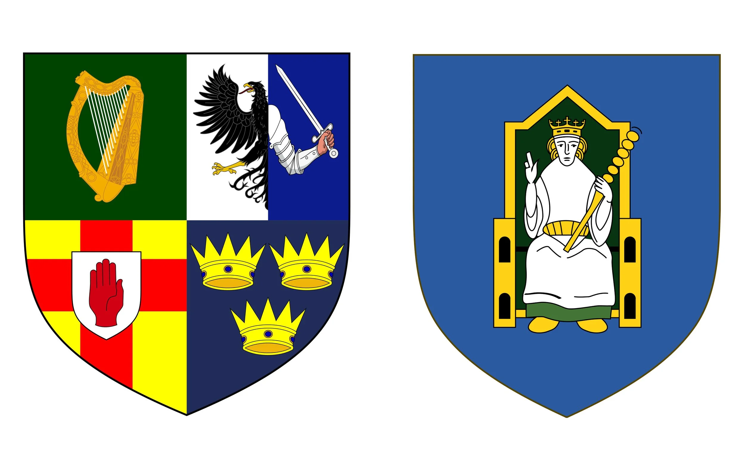
The unofficial Four Provinces arms (left), and the old Meath arms (right)
Where the provinces were ancient, the counties were imposed later, largely as a way to dismantle Gaelic power and replace it with English law, tax, and administration. The process began with the Anglo-Norman invasion of 1169, the Normans seizing land and reorganising it into their own “shires”. Ireland's provinces were formally subdivided into counties by King John. The earliest counties — Dublin, Kildare, Wexford, Waterford, Cork, Limerick — existed only where English military power was secure. The rest of Ireland remained under Gaelic rule.
Tudor ambition changed everything. Henry VIII and Elizabeth I wanted to conquer the entire island and impose English law universally. In the 1550s, the Laois and Offaly plantations marked the first systematic attempt to replace an Irish population with English settlers. The Settlement of Laois and Offaly Act 1556 created Queen's County and King's County, with two new shire towns: Maryborough and Philipstown were named in honour of Queen Mary I and her husband King Philip II of Spain (it was not, as is sometimes said, named for an Irish king). Both names were deliberate attempts at stamping royal identity onto seized Gaelic land.
Elizabeth’s regime then broke Connacht into counties, even temporarily transferring Clare from Munster to use the Shannon as the provincial boundary. The 1607 Flight of the Earls (the departure of the remaining Gaelic chieftains) made the Ulster Plantation possible, and the Ulster territories were mapped and divided into counties. With the creation of Wicklow in 1606 (carved out of south Dublin) the map of Ireland's 32 counties was effectively complete.
(King's and Queen's Counties kept those names until 1922, when they were renamed Offaly and Laois by the new Irish Free State. The new names refer back to the ancient Gaelic clans who had held the land before 1556: Laois from Uí Laoighis, and Offaly from Uí Failghe. Maryborough and Philipstown were simultaneously Gaelicised as Portlaoise and Daingean. Of course the renaming was a symbolic act, but it was done without legislation: the old “royal” names still had to be used in certain legal documents until 2001, when the Local Government Act finally set the new names into law.)
These two overlapping frameworks are so familiar we don’t even think about the history behind them. It was the simple question “what are the provinces for?” that sent me off chasing this subject. And, honestly, outside of sports (and 32 counties in 4 provinces is tailor-made for a championship format), they might not have much visible impact on the country. But it’s hard to imagine the old place without them: they obviously have a kind of cultural weight that all our centuries of war, tumult and invasion never managed to erase.
As a final note, each county had an associated county town where county courts were held. The assize court (where judges travelled from Dublin to hear serious cases) was the defining institution of a county town. So the question was not which town was largest or wealthiest, but which could most practically serve as the county’s judicial and administrative centre. For the earliest counties, following Norman military logic made it straightforward. The Normans built their castles at strategically defensible positions and the settlements that grew around them were the natural administrative hubs. In fact it was sometimes even more fundamental than that: many of the earliest county towns already existed as ecclesiastical settlements before the Normans arrived, so they already functioned as regional gathering points.
The Tudor plantations, creating counties where there were no suitable existing settlements, often deliberately planted shire towns (like Maryborough and Philipstown, as mentioned earlier). These were essentially English garrisons in hostile territory, and chosen (or built) at a defensible point.
As well as political and military considerations, and basic accessibility, proximity to the geographical centre of the county was also a major factor: the town should be within one legal day’s ride of any other part of the county.